These data come mostly from my diploma work, in case you want to use data from these page please cite my work like this :
"Bochud, M., 2006. Tectonic evolution of the Eastern Greater Caucasus. Diploma Thesis, University of Fribourg, Fribourg, 92 pp."
Introduction
The Eastern Greater Caucasus is located in the north of Azerbaijan near the Caspian Sea. The southern part of this sea is presently one of the deepest intra-continental basins in the world. In fact, it is almost impossible to know the exact lithology and origin of the basin basement because it is very deep (more than 20km). It is filled at least with 15 km of sediments. One solution is to explore the different surrounding mountain belts to find some geological feature that can explain its evolution. The Greater Caucasus is one of these mountain belts. Probably a major part of the basin sediments were eroded from the Eastern Greater Caucasus and transported by the Paleo-Volga River, the Paleo-Kura River and their tributaries. The aim of our projects is to explain the evolution of the Eastern Greater Caucasus and to give some new data for explaining the basement origin of the South Caspian Basin.
The Middle East is one of the most important areas for hydrocarbon resources in the world. The Caspian Sea and especially Baku, the capital of Azerbaijan, are famous since the Antiquity for their petrol. In the beginning of the 20th century numerous European investors have made their fortune in Baku (e.g. Nobel Family).
The Eastern Greater Caucasus orogen is related to the Arabia-Eurasia collision. It contains remnants of a sedimentary basin, the Greater Caucasus Trough. It was the link between the Black Sea and the South Caspian Sea from the Jurassic until the Eocene. Now these rocks crop out and are probably of the same origin as the South Caspian basement rocks. The study of the evolution of the Eastern Greater Caucasus can provide numerous information about the evolution of the Caspian region.
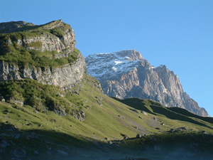
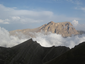
The tectonic features and structural relationships are well exposed in the incised river valleys of the northern and southern slopes of the Eastern Greater Caucasus but also in the high cliffs and steep slopes of the central mountain range. The average altitude of the relief is about 2000m a.m.s.l. and culminates 4466m a.m.s.l. with Bazarduzu Mountain. The others famous summits of Azerbaijan are the Tufan dag, the Sahdag, the Qizilqaya, the Baltaqaya and the Babadag.
Since 2003, we did several expeditions :
- 4 to 15 May 2004 : Overview of the Eastern Greater Caucasus (MEBE project)
- 8 august to 24 september 2004 (pictures) : 5 weeks in the southern part and 10 days in the northern part of the EGC (ASSN project)
- 4 to 13 September 2005 (pictures) : mostly the northern part of the EGC (MEBE project).
- 4 August to 13 September 2006 : northern part of the EGC (SCOPES and ASSN project) .
- 21 Augsut to 14 September 2007 : Lesser Caucasus near Ganja and afterthat the southern and northern parts of the EGC (SCOPES project).
- 8 to 29 June 2008 : northern, southern and western part of the EGC(SCOPES project).
Caucasus general geological context
The Greater Caucasus forms a linear collisional mountain belt along the southern border of the East European Platform. It separates the latter from the Arabian / Turkish plates. It lies north of both Black Sea and South Caspian Basin.
A key feature of the Arabia–Eurasia collision is the presence of trapped blocks of rigid crust between the Eurasia continent and the Arabian - Turkish plate (South Caspian Sea, East and West Black Sea). These blocks are surrounded by active fold and thrust belts (Greater Caucasus, Alborz, Kopet Dagh, …). (Allen et al., 2003).
Molasse basins and different tectonic units around the Greater Caucasus orogen are shown in Fig. 4. In the north, the western Indol – Kuban Basin and the eastern Terek-Caspian Basin are the deepest parts of the Northern Caucasus molasse basins. They are separated by the basement uplift of the Stavropol High. In the south, the western Rioni and the eastern Kura molasse basins are bound southward by the Lesser Caucasus Mountains, eastward by the South Caspian Basin in the east and westward by the Black Sea. (Ershov et al., 2002).
Structurally the Greater Caucasus is the deformed southern margin of the Late Paleozoic Scythian Platform. This platform extends along the southern margin of the Russian Platform. It is bound in the north by the Karspinsky Swell, which formerly was a part of the Dnieper-Donets-Karpinsky rift system. Now it is the peripheral bulge of the Northern Caucasus Molasse Basin. (Ershov et al., 2002).
The present structure of Greater Caucasus exposes its Paleozoic basement in dominantly southward-directed thrust slices only west of longitude 44°E. The Jurassic and Cretaceous series are present in tight or isoclinal folds associated with thrust across the range around the exposed Paleozoic core. The vergence of folds is predominantly towards the south. Plio-Quaternary strata are folded into elongated, linear south vergent anticlines on the southern side of the range (between the Kura and Rioni basins). However there are north directed structures on the northern margin, especially in the northeast. The Moho under the range is at depth of up to 60 km. (Allen et al., 2003).
Eastern Greater Caucasus geological context
The overall geodynamic setting of the Eastern Greater Caucasus corresponds to a continental collision inverting the former passive margin of the Scythian plate. The tectonic features of the Eastern Greater Caucasus are those of a doubly verging mountain belt with two external fold-and-thrust belts. The pro-wedge (front) is located to the south and overrides the Kura Basin, whereas the retro-wedge (back) is located to the north and overrides the Terek Basin.
Northern part
The northern part is mostly characterized by platform and shelf deposits. It is delimited by three important thrusts: the Siyazan thrust on the north and the Sahdag-Germiyan thrust relayed by the Garamvar thrust on the East.
- The Ukurcay-Tahircal zone contains mostly sandstone and argillites of the Lower Jurassic.
- The Sudur transition zone is composed from terrigenous-carbonate sequences of the Upper Jurassic, Lower Cretaceous and rarely of Upper Cretaceous and Paleocene-Neogene rocks.
- The Sahdag – Xizi zone can be divided in two parts: the autochthonous complex and a part with numerous olistostromes. The autochthonous complex is composed of argilo-calcareous sequences of the Lower Cretaceous and in the core of the anticline terrigenous formations of the Middle-Upper Jurassic can be found. The olistostromes are mainly formed with Upper Jurassic rocks. They fell in Hauterivian rocks. In the east, there are even folded olistoplates with almost one kilometre scale.
- Finally the Qusar tectonic zone is a superimposed basin with continental-marine molasses of the Neogene and in the south limb argilo-calcareous sequences of Cretaceous-Paleogene can be observed.
- Structurally the northern part is characterized by a nappe – the Sahdag-Beshbarmaq Nappe - that thrust over several kilometres the folded Jurassic and Cretaceous deposits. Later it underwent an inversion due to the uplift of the Tufan zone. Due to this inversion, the root zone of this klippe is presently under the klippe (Tangyaalti canyon and Cirax Mountain). The base of the nappe is from the Upper Jurassic and some Upper Pliocene rocks crop out at the summit (e.g. on the top of the Sahdag Mountain 4243 m).
- An important transgression was observed in the same region and dated of Turonian age further to the east (Xizi area) and of the Campanian age in the west (Budur and Sahdag zones). These deposits correspond to the Neoautochthonous complexes.
In the present day geomorphology, the northern part is clearly incised by big and deep valley. The rivers flow in an average north-eastern direction and finally reach the Caspian Sea.
The central and southern parts are characterized by slope and basinal deposits. They are delimited to the north by the Sahdag-Germiyan-Garmavar thrusts and to the south by the Dengebiz thrust.
Central and southern part
First, the Tufan zone is principally composed of Middle Jurassic sandstones and argillites. It is formed by 2-3 broad anticlines with cores in Aalenian rocks. Outcrops are mainly turbidite deposits of several kilometres. The highest summits of the Azerbaijan (Bazarduzu 4466 m and Tufandag 4191m) are located in this area.
- The Qovdag-Sumgayit zone (or also "Mother zone") comes after and is composed of terrigeneous-carbonate rocks of the Cretaceous, Paleogene and Neogene. It is composed of a large fault-related syncline and several middle scale thrusts. (Berberian, 1983).
In the south of this zone the important Basqual - Perekishkul Nappe was displaced during the Upper Miocene. The southern extension of these units forms a flat lying thrust unit, the Basqual Nappe. This nappe overrides deeper thrusts and fold structure of sedimentary units of the Vandam geoanticline.
- The Vandam geoanticline is composed principally of argileous-calcareous sequences of the Lower Cretaceous and terrigeneous - volcanogenic rocks of the Upper Cretaceous.
The root zone of the Basqual - Perekishkul Nappe (Southern root zone) is located to the south of the Qovdag-Sumgayit zone. It crops out very well in the Girdimancay Valley just below Burovdal Village.
At the limit of Kura Basin and Alazani Basin, there is an important anticline – the Karamarian anticline – developed in Quaternary deposits and probably linked with an active blind thrust.
Generally, in the southern slopes of the Eastern Greater Caucasus, the geomorphology of the valley is different from the northern slopes. There are also large incised valleys but the flow direction is slightly different. Rivers after a short flow in the south-eastern direction take almost an eastern direction before reaching the South Caspian Basin.